Meteo-Oceanographic buoys are launched by NOc Antares of the Brazilian Navy along the Southeast Coast of Brazil
18-04-2015
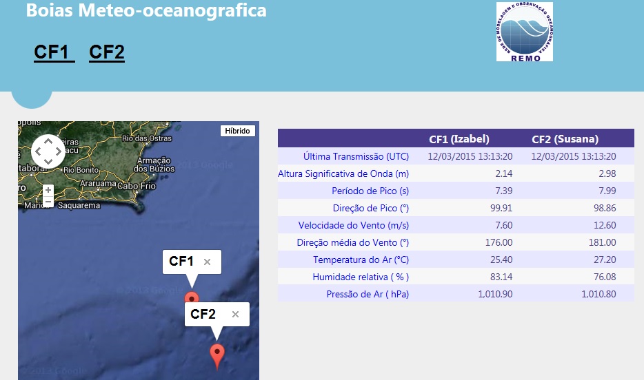
The NOc Antares of the Brazilian Navy launched two REMO buoys in March 2015. The buoys are collecting and transmitting atmospheric and oceanic data. They are equipped with sensors to measure (i) winds at 3 m; (ii) air temperature at 2 m (iii) surface atmospheric pressure, (iv) surface relative humidity; (v) significant height, peak period and surface wave peak direction; (vi) currents up to 100 m; and (vii) water temperature of 10 by 10 m up to 100 m depth. This data will mostly be transmitted to the Global Transmission System (GTS) and will have public domain. The data can soon be accessed through the REMO website www.rederemo.org, along with short-term oceanographic forecasts prepared operationally by the Brazilian Navy's Hydrographic Center (CHM).
The basins were called CF1 and CF2, considering that they are close to Cabo Frio. They are based on a water depth of 300 m (CF1) and 2000 m (CF2) at the geographic positions -23.7703º W (CF1) and -24.1903º W (CF2).
All physical structure, including its transmission components, are national. The sensors are imported.
These buoys are a milestone for REMO and Petrobras in their role of supporting the scientific and technological development of operational oceanography in Brazil since 2008.